Moab is known as an outdoor playground. Whether you like to drive the trails in a Jeep, cruise the track on a bike or hike to view truly natural wonders, Moab has it all. Utah as a whole draws 11.3 million visitors a year to the state’s five national parks. In Moab alone, over a million people visit Arches each year, while Canyonlands fluctuates between 500,000 and 750,000 visitors each year. The popularity means long lines to get in, the need to book reservations, packed trailheads and slowdowns on the main park roads. However, you can experience the beauty of Moab without having to visit Arches or Canyonlands. Here are four kid-friendly trails to see the unique beauty of the area.

Corona Arch
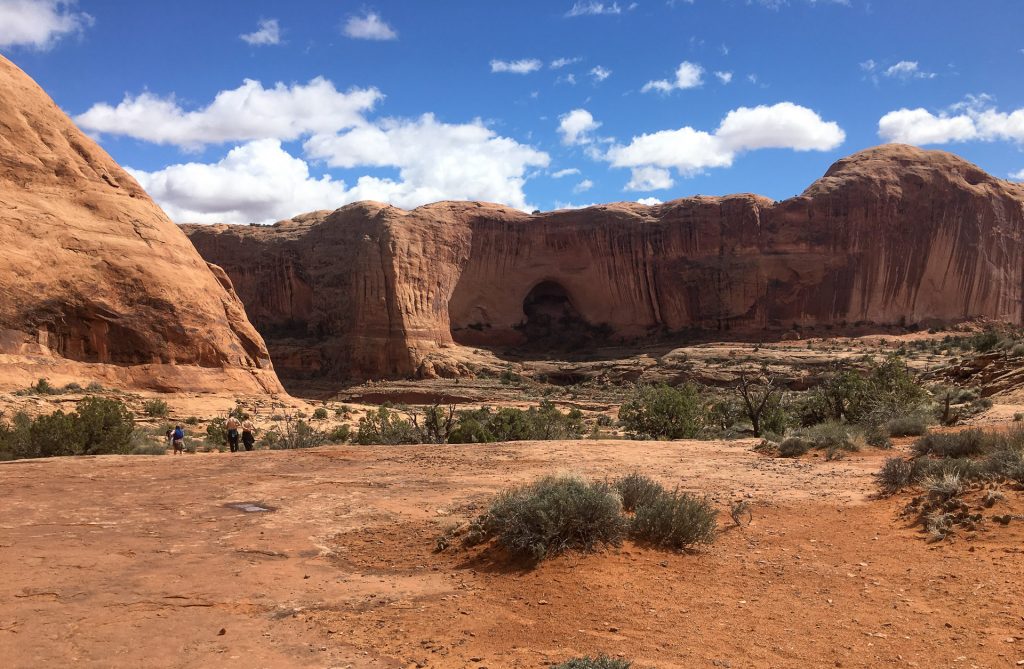
This 3-mile out-and-back hike is located off the Utah Scenic Byway/Potash Road. It features a mix of slick rock and sand. Green arrows and cairns will guide your way to the natural beauty of a 140- by 105-foot sandstone arch. Sometimes referred to as Little Rainbow Bridge, some say it got its name because it looks like a solar flare.
You will also get an up-close view of Bowtie Arch, a pothole arch. From afar, you can see Pinto Arch as you head toward both Bowtie and Corona arches.
This hike is rated moderate due to the two cable sections, moki steps and a 6-foot ladder you must use to climb down and up. There is an elevation change of less than 500 feet, but the trail is often off-camber. Young kids with steady feet will love this hike but may need a boost or guiding hand.

There is no shade on this hike, so it is recommended that you get out early in the warmer months. It should take about 1.5 hours to complete the hike, depending on how long you stay at the arch.
Be sure to stop off at the dinosaur trackway and petroglyph panel also off Potash Road. Park at the Poison Spider trailhead, and be ready for some climbing and scrambling. It is less than a half-mile hike. Across the road from the trailhead, you can find bathrooms at the Gold Bar Campground and Recreation site. There is no fee to hike this trail.

East And West Rim Trails, Dead Horse State Park
The filming location of the ending scene of Thelma & Louise, many scenes from HBO’s Westworld and many more TV shows and movies, Dead Horse State Park brings with it a lot of tales, one of which its name comes from. Used as a natural corral in the 19th century, the trail is said to be visited by the ghosts of horses that died from exposure.

The East Rim Trail begins at the visitor center and takes you along the mesa, ending at Dead Horse Point. This basically flat trail is 2 miles one way, including the Basin Overlook Spur. Spectacular views of Behind the Rock and the La Sal Mountains greet you at every step along the rim.

Continue on from Dead Horse Point (an Instagram-worthy spot) to hike the West Rim Trail. By combining the two trails, you can hike 4-plus fairly flat miles. The West Rim features many spur trails, including Shafer, Meander and Rim Overlook, that add a mile to the trail but are well worth it for the views. This trail is less visited than the East Rim Trail and has more natural features and slick rock. Cairns will help guide you through the less obvious parts of the trail. Views of the Colorado River and Shafer Canyon are highlights of the trail.

Be aware that these trails are also open to mountain bikes and leashed dogs, so keep your eyes and ears open. Water and restrooms are available at the visitor center. There is a $20 day-use fee for entry into the park.

Grandstaff/Morning Glory Bridge Trail
Just 5 miles outside of town on Utah Scenic Byway 12, the Grandstaff Trail takes you to the 243-foot-long Morning Glory Natural Bridge, one of the largest natural bridges in the world. Some may call it Morning Glory Arch, as some geologists believe it isn’t a natural bridge but rather an alcove arch.

There is less than 800 feet of elevation gain over this fairly easy out-and-back 5.5-mile trail. The trail features several water crossings. Depending on the time of year, you may be able to use rocks and logs to navigate the crossings without getting your wet feet. Most often, though, you will need to walk through some water. The best choice is to wear waterproof shoes or sandals (Chacos, etc.) to hike this trail.

Taking you through Grandstaff Canyon, this hike is one that actually features shade. The tall canyon walls are home to many birds and offer a respite from the intense sun. Cottonwoods also offer shade and abundant fall color. Poison ivy is prevalent along this trail.
Leashed dogs can also enjoy some time in the water and beautiful scenery. This area is popular with rappelers, so don’t be surprised if you see a few in the bridge area. There is no fee to hike this trail. Pit toilets are located at the trailhead.

Mary Jane Slot
One of the few slot canyons in the area that doesn’t require special equipment, the 9-mile hike into Mary Jane Slot is the perfect cool-down hike. Two trails lead from the trailhead parking lot. On the right is the Professor Creek/Sylvester Trail. Although it’s named after the homestead of Professor Sylvester Richardson that was at the mouth of the creek in 1886, a school also once stood at the site, as well as a post office and store. Take the trail on the left-hand (southeast) side, named for Sylvester’s wife Mary Jane, to head toward the Mary Jane slot.

Be sure to wear proper footwear for this hike, as you will get your feet wet at the water crossings. You can also negate much of the 500-plus-foot elevation gain by walking directly in the water. To see the hidden 30-foot waterfall, you have to enter the water. Waterproof trail runners or hiking boots, closed-toe sandals and Chacos are all good choices. Be prepared to have to dump a little sand or rocks out of your shoes at some point along the hike.
While the mileage seems long, it goes by fast. The changing landscape, high canyon walls and water all bring a fun element to it that kids enjoy. They will also like leaving their prints on the wall near the waterfall. If the mileage seems too long, the trail is an out-and-back. You can turn around at any time. The canyon walls begin to close in around 2 miles, and water access occurs from a half-mile on.

There is no bathroom or access to water at this trailhead. There are spots of shade, but not too much can be found on the hike. Poison ivy is prevalent along the trail. There is no fee to hike this trail. Pups will enjoy romping in the water on this hike.


